|
||||
|
||||
|
![]()
![]()
![]()
![]()
![]()
![]()
Wall Maps > Middle America Political Map
-
Sale $89.99
- $359.99 (free shipping/handling)
Retail: $
115.00- $395.00
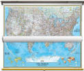
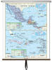
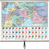
Central America - Political Classroom Wall Map on Roller Item: CM911701632001
|
|
The Central America Essential Classroom
Wall Map includes physical features and political boundaries, national
capitals, cities, major waterways, and longitude/latitude lines; and
Mexico, all of Central America, plus the Bahamas, Cuba, Haiti, Dominican
Republic, Jamaica, the Leeward Islands, and the Lessser Antilles. Shaded
relief highlights physical features of the continent.
Wall map measures 54" x 69". Continent Essential Series features an enhanced legend and pictorial landform illustrations for intermediate level use. Also shows deserts & wetlands. The inset map locator illustrates the location of each continent in the world. Appropriate for grades 4-8. This product is ideal for public, private, parochial, and home schools.
|
|

Call us toll-free 877-822-9889 or 812-333-2772 for orders/questions Mon.-Sat. 10:00 am-5:30 pm Eastern Standard Time
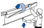
Large mounted Central America wall map
| 7 Continents National Geographic Map Set | US / World National Geographic Set | US / World Combo Sets | World Wall Maps | USA Wall Maps |
 |
 |
 |
 |
 |
| $999.99 (free ship/h) | $314.99 (free ship/h) | $319.00 (free ship/h) | $64.99 - $364.99 (free s/h) | $64.99 - $364.99 (free s/h) |
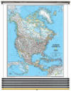
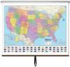
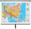
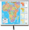
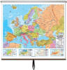
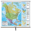
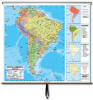
| Asia Wall Map | Africa Wall Map | Europe Wall Map | North America Map | South America Map |
 |
 |
 |
 |
 |
| $99 - $250 (free s/h) | $99 - $250 (free s/h) | $99 - $250 (free s/h) | $99 - $250 (free s/h) | $99 - $250 (free s/h) |
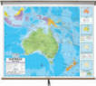
| Australia Wall Map | Central America Map | Middle East & S. Asia | ||
 |
 |
 |
 |
|
| $99 - $250 (free s/h) | $199.00 (free ship/h) | $199.00 (free ship/h) | ||