|
||||
|
||||
|
![]()
![]()
![]()
![]()
![]()
![]()
Wall Maps > Multiple Pull Down Wall Map Sets
CLASSROOM WALL MAP SETS ON ROLLERS - Custom Sets
-
Sale
Price: $649.99
- $1599.99 (free
shipping/handling)
or 6 monthly installments of
with
PayPal Credit Retail Price:
$
899.00-$1899.00
Use COUPON CODE "MAP10" for an additional 10% DISCOUNT for multiple Map Sets
|
Mix & Match Wall
Maps customized to your needs: choose from a wide selection of Political,
Physical, and Historical wall maps - covering the United States, World,
Continents, Regions, States, Counties, Cities, Blank Panels, etc.
All maps in the set are designed with the same
width for a uniform and cohesive display.
How to Order:
Features: |
|
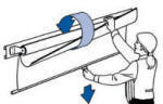
Make the best use of your space with these multi-map rolled sets, mixing and matching any Continent wall map title in the Advanced Political, Physical (see below) or Essential Wall Map series. Include a wealth of geographic information: country boundaries, national capitals, large cities, major waterways, longitude/latitude lines, mountain ranges, rivers, lakes, deserts and more. All maps are printed on high quality, tough, non-tear paper. Wall Maps are a great addition to any classroom or office. In addition to political boundaries color coding, shaded relief highlights physical features. World map inset highlights location of continent. Appropriate for grades 6-12, and includes content that meets national and state curriculum standards. Four thematic inset maps enhance the value of the main map, featuring: climate; natural vegetation and environment; population density per square mile and ethnic diversity; and landforms and regions. All maps in this series are markable with a dry erase or water-soluble marker. Durably laminated maps are mounted on roller with backboard. Please allow 6-14 days for delivery on multiple wall map custom sets.
|
||
|
The Advanced Physical Wall Map series features innovative shaded relief detail of the world, continents, and the United States. This high quality classroom wall map series is appropriate for grades 6-12, and includes content that meets national and state curriculum standards. Four thematic inset maps enhance the value of the main map, featuring: annual rainfall; elevation profile; natural vegetation areas, plus areas of acid rain; population density per square mile and ethnic diversity; and energy resources and manufacturing areas. The world map features the Van Der Grinten projection. Please allow 6-14 days for delivery on multiple wall map custom sets.
|
||
|
|||
|
ESSENTIAL WALL MAP SET
Classroom wall maps clearly identify political country boundaries, with shaded relief highlighting the physical features of land masses. Capitals, major cities, bodies of water, latitude and longitude lines are included. A world inset map shows the location of each continent.
|
|||
|
|
|||


Political Maps
[Continent_Sets_Roller/Continent_Political_Maps_Price_List.htm]Additional map images can be viewed here
Physical Maps
[Continent_Sets_Roller/Physiical_Continent_Maps_Price-List.htm]Additional map images can be viewed here
Large Mounted Rolled Series World Wall Maps