|
||||
|
||||
|
![]()
![]()
![]()
![]()
![]()
![]()
|
||||
|
||||
|
![]()
![]()
![]()
![]()
![]()
![]()
Sale
Price:
$139.99 -
$589.99 (free
shipping/h)
or 6
monthly installments with
PayPal Credit
Retail
$135.00 - $639.00
|
Wall map panel measures: 64" x 50" This map covers boundaries extending:
Key features include:
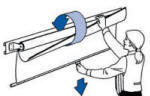
The laminated surface features a heavy-duty, washable finish that can be written on with water-based or wet-erase markers, ensuring years of reusable, hands-on use. Please click here to view Map Mounting Setup Options
|
|
||||||||||||||||||||
|
|||||||||||||||||||||
Hurricane Tracking Chart Map by KP, Item # 911000062001
Sale Price: $99.99 - $559.99.00 USD, Wall Map, Geography, Science, Education, Maps, Geography
Home | Products | About
Us | Contact
Us | Helpful
Links | Order,
Return
& Privacy Policies | Site
Map | International
Orders
Site Map | Privacy
Policy | Easy
Return/Exchanges | APO/FPO
Orders | No
Minimum Order + FREE
Shipping (contiguous USA)
e-mail:
traveler@1ststoptravelstore.com
Address:
317 East Dodds Street,
Bloomington, IN 47401 USA
Telephone:
812-333-2772
Toll Free:
877-822-9889
Mon.-Sat.
10:00 am-5:30 pm EST (10:00-17:30)
Our Shopping Cart - holds a Secure Web Server
Certificate by McAfee and offers PayPal, Venmo, Coinbase and major credit cards
for your convenience.
![]()
![]()
![]()
![]()