|
||||
|
||||
|
![]()
![]()
![]()
![]()
![]()
![]()
|
||||
|
||||
|
![]()
![]()
![]()
![]()
![]()
![]()
Durably Laminated U.S. History Classroom Wall Maps
Available as individual maps or multi-map sets, these wall maps are ideal for public, private, parochial, and home schools—as well as history lovers everywhere.
Please click here to view Map Mounting Setup Options Mounting hardware is included with your map order. When ordering a set, please indicate map item number and title in the Special Instructions Section of the secure Shopping Cart below or via email to: traveler@1ststoptravelstore.com. |
|
|||||||||||||||||||||||||||
Purchase Orders Accepted - U.S. educational institutions and government agencies can place orders via official purchase order. Please email your PO to traveler@1ststoptravelstore.com
|
||||||||||||||||||||||||||||
|
Please scroll down to view images of all history maps offered (arranged by approximate dates) |
|||
|
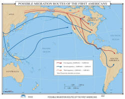
Migration Routes of the First Americans -
US History Wall Map Item # 30002 Sale: $99.99 - $539.99 (free ship/h) Wall map identifies the Possible Migration Routes of the First Americans, originating in Asia they work through North and South America during three historical periods: 35,000 BC – 18,000; 10,000 BC – 4,000; and 8,000 BC – 3,000 AD. |
 |
|
|
|
|
|||
|
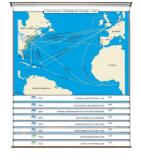
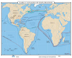
Early Exploration - US History Wall Map Item # 30005 Sale: $99.99 - $539.99 (free ship/h) Wall map charts the paths of Magellan, Drake, Ponce de Leon, Cortez, and others, to the New World. |
 |
|
|
|
|
|||
|
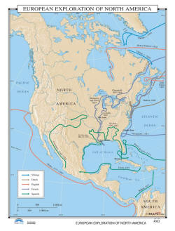
European Exploration of N. America - US History Wall Map Item # 30008 Sale: $99.99 - $539.99 (free ship/h) Wall map shows where five European groups and key explorers traveled: Norse, Dutch, English, French, and Spanish. The map features the individual routes taken by Cabot, Champlain, Marquette, De Soto, Balboa, and others. |
 |
|
|
|
|
|||
|
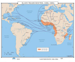
Slave Trade Routes, 1400s to 1800s - US History Wall Map
Item # 30011 Sale: $99.99 - $539.99 (free ship/h) African slaves were not just sold to southern plantation owners in the United States. Slave Trade Routes, 1400s – 1800s shows the routes taken by slave traders out of southern Africa. |
 |
|
|
|
|
|||
|
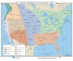
Native Americans, 1500s - US History Wall Map Item # 30014 Sale: $99.99 - $539.99 (free ship/h) Wall map features the cultural regions of the Native Americans. This map includes shaded relief on many areas, and provides a commanding overview of the entire United States from 1500-1600. |
|
|
|
|
|
|||
|
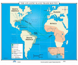
Atlantic Slave Trade Routes - US History Wall Map Item # 30017 Sale: $99.99 - $539.99 (free ship/h) The shaded areas on this classroom wall map identify the Slave, Gold, and Ivory Coasts; along with slave gathering areas, major concentrations of slaves, slave trading forts, and the routes of the slave traders. |
|
|
|
|
|
|||
|
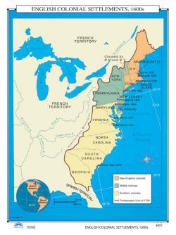
English Colonial Settlements, 1600s - US History Wall Map Item # 30020 Sale: $99.99 - $539.99 (free ship/h) Wall map identifies three major areas of settlement in the new country: the New England Colonies, the Middle Colonies, and the Southern Colonies; and includes the Proclamation Line of 1763. |
 |
|
|
|
|
|||
|
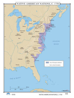
Native American Nations - US History Wall Map Item # 30023 Sale: $99.99 - $539.99 (free ship/h) A number of Native American Nations populated the North American continent in 1750. This map shows many of the settlements east of the Mississippi River, along with the primary area of European settlements. |
 |
|
|
|
|
|||
|
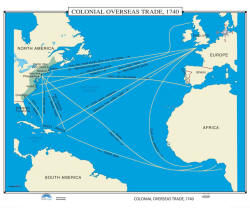
Colonial Overseas Trade - US History Wall Map Item # 30026 Sale: $99.99 - $539.99 (free ship/h) Colonial Overseas Trade, 1740, was very active, with trade running in both directions. North Americans were shipping items like grain, rum, fish, lumber, furs, livestock, and tobacco to the European and African continents. |
 |
|
|
|
|
|||
|
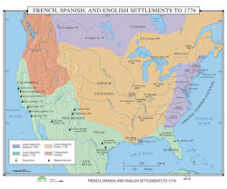
English, French & Spanish Settlements in N.
America, 1776 - US History Wall Map of Item # 30029 Sale: $99.99 - $539.99 (free ship/h) Wall map showcases the areas claimed by three cultures which dominated settlement in North America in 1776. |
 |
|
|
|
(1) 35,000 BC - 1776 AD (2) 1776 - 1812 (3) 1846 - 1857 (4) 1860 - 1877 (5) 1870 - 1941 (6) 1949 - 1999 (7) Wars Abroad |
|||
|
|
|||
|
|
Are you placing an order for a school or nonprofit?
Please submit your valid exemption certificate to traveler@1ststoptravelstore.com
Call us toll-free 877-822-9889 or 812-333-2772 for orders/questions Mon.-Sat. 10:00 am-5:30 pm Eastern Standard Time
United States History Pull Down Classroom Wall Maps on Rollers by KP, Item # 300xx
Sale Price: $119.99 - $1249.99, Educational pull down world maps for students of history, classroom maps on rollers, school maps, spring roller maps, roll down maps for classrooms, large world maps
|
Home | Products | About Us | Contact Us | Helpful Links | Order, Return & Privacy Policies | Site Map | International Orders |
||||||||||||||
|
|
|||||||||||||
|
Site Map | Privacy Policy | Easy Return/Exchanges | APO/FPO Orders | No Minimum Order + FREE Shipping (contiguous USA) |
||||||||||||||