|
||||
|
||||
|
![]()
![]()
![]()
![]()
![]()
![]()
|
||||
|
||||
|
![]()
![]()
![]()
![]()
![]()
![]()
Durably Laminated U.S. History Classroom Wall Maps
Available as individual maps or multi-map sets, these wall maps are ideal for public, private, parochial, and home schools—as well as history lovers everywhere.
Please click here to view Map Mounting Setup Options Mounting hardware is included with your map order. When ordering a set, please indicate map item number and title in the Special Instructions Section of the secure Shopping Cart below. |
|
|||||||||||||||||||||||||||
|
Purchase Orders Accepted - U.S. educational institutions and government agencies can place orders via official purchase order. Please email your PO to traveler@1ststoptravelstore.com
|
||||||||||||||||||||||||||||
|
To order single history maps please use "Add to Shopping Cart" buttons next to each map (arranged by approximate dates) |
|||
|
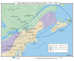
The French & Indian War-
US History Wall Map Item # 30032 Sale: $99.99 - $539.99 (free ship/h) |
 |
|
|
|
|
|||
|
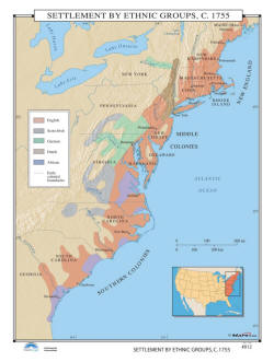
Settlement by Ethnic Groups, 1755 - US History Wall Map Item # 30035 Sale: $99.99 - $539.99 (free ship/h) America has been a cultural melting pot since the very beginning. The Settlement by Ethnic Groups, 1755 classroom wall map uses colorful shading to identify major groups of English, Scots-Irish, German, Dutch, and African settlers. |
 |
|
|
|
|
|||
|
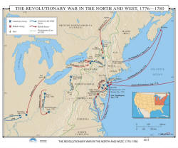
Revolutionary War - US History Wall Map Item # 30038 Sale: $99.99 - $539.99 (free ship/h) Wall map shows both American and British victories; troop movements for American, Allied, and British forces; the Proclamation Line of 1763; and fort locations. |
 |
|
|
|
|
|||
|
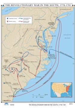
Independence War in the South - US History Wall Map
Item # 30041 Sale: $99.99 - $539.99 (free ship/h) Colorful blue and red lines identify American and British troop movements and victories during the The Revolutionary War in the South, 1778-1781. The generals leading the troops into battle are also identified, along with the actual names of the battles. |
 |
|
|
|
|
|||
|
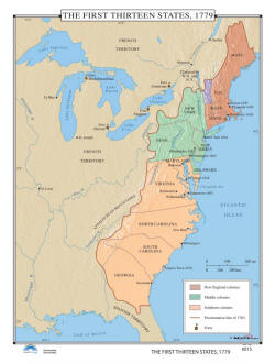
The First Thirteen Colonies - US History Wall Map Best Seller Item # 30044 Sale: $99.99 - $539.99 (free ship/h) The First Thirteen States, 1779 are shown in vivid graphic format on this school wall map. Including some shaded relief, the New England colonies, Middle colonies and Southern colonies are all shown in separate colors. Also shown are forts in 1779, as well as the Proclamation line of 1763. |
 |
|
|
|
|
|||
|
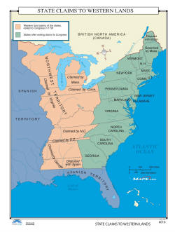
State Claims to Western Lands - US History Wall Map Item # 30047 Sale: $99.99 - $539.99 (free ship/h) In the late 1700s-early 1800s, states made various claims to what were then the Western lands. State Claims to Western Lands identifies the Western land claims of the states ceded to Congress in 1791. |
 |
|
|
|
|
|||
|
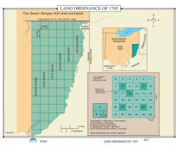
Land Ordinance of 1785 - US History Wall Map Item # 30050 Sale: $99.99 - $539.99 (free ship/h) The Land Ordinance of 1785 – passed by Congress on May 20, 1785 – allowed for the sale of land in the Northwest Territory and set up standards for land sale that became precedent. This map shows the seven ranges first surveyed. |
 |
|
|
|
|
|||
|
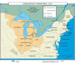
Northwest Territory, 1787 - US History Wall Map Item # 30053 Sale: $99.99 - $539.99 (free ship/h) The Northwest Ordinance of 1787 allowed for the creation of the Northwest Territory, 1787. Five states were created in this land, east of the Mississippi River and between the Ohio River and the Great Lakes. |
 |
|
|
|
|
|||
|
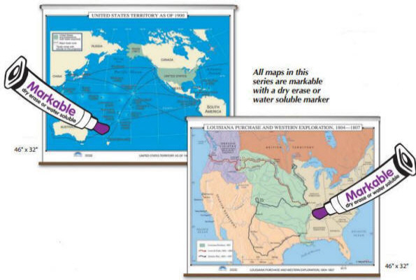
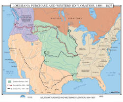
Louisiana Purchase - US History Wall Map Item # 30056 Sale: $99.99 - $539.99 (free ship/h) Louisiana Purchase & Western Exploration, 1804-1807 follows Lewis and Clark’s 1804-0806 expedition from St. Louis, through the Louisiana Purchase area and Oregon Country, to the Pacific; and Zebulon Pike’s 1805-1807 expedition through Louisiana and Spanish Territory. |
 |
|
|
|
|
|||
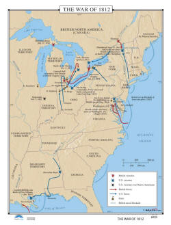
|
War of 1812 - US History Wall Map Item # 30059 Sale: $99.99 - $539.99 (free ship/h) Follow the British and US victories in The War of 1812 in North America. Also included are: US victories over Native Americans, British troop moments, US troop moments, forts, and the British Naval Blockade. |
 |
|
|
|
(1) 35,000 BC - 1776 AD (2) 1776 - 1812 (3) 1846 - 1857 (4) 1860 - 1877 (5) 1870 - 1941 (6) 1949 - 1999 (7) Wars Abroad |
|||
|
|
|||
|
|
Are you placing an order for a school or nonprofit?
Please submit your valid exemption certificate to traveler@1ststoptravelstore.com
Call us toll-free 877-822-9889 or 812-333-2772 for orders/questions Mon.-Sat. 10:00 am-5:30 pm Eastern Standard Time
United States 18th Century History Pull Down Classroom Wall Maps on Rollers by KP, Item # 302xx
Sale Price: $119.99 - $899.99, Educational pull down world maps for students of history, classroom maps on rollers, school maps, spring roller maps, roll down maps for classrooms, large world maps
|
Home | Products | About Us | Contact Us | Helpful Links | Order, Return & Privacy Policies | Site Map | International Orders |
||||||||||||||
|
|
|||||||||||||
|
Site Map | Privacy Policy | Easy Return/Exchanges | APO/FPO Orders | No Minimum Order + FREE Shipping (contiguous USA) |
||||||||||||||