|
||||
|
||||
|
![]()
![]()
![]()
![]()
![]()
![]()
|
||||
|
||||
|
![]()
![]()
![]()
![]()
![]()
![]()
Durably Laminated U.S. History Classroom Wall Maps
Available as individual maps or multi-map sets, these wall maps are ideal for public, private, parochial, and home schools—as well as history lovers everywhere.
Please click here to view Map Mounting Setup Options Mounting hardware is included with your map order. When ordering a set, please indicate map item number and title in the Special Instructions Section of the secure Shopping Cart below.
|
|
|||||||||||||||||||||||||||
|
Purchase Orders Accepted - U.S. educational institutions and government agencies can place orders via official purchase order. Please email your PO to traveler@1ststoptravelstore.com
|
||||||||||||||||||||||||||||
|
To order single history maps please use "Add to Shopping Cart" buttons next to each map (arranged by approximate dates) |
|||
|
Western Railroads & Cattle Trails -
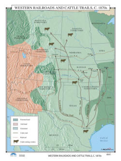
US History Wall Map Item # 30122 Sale: $99.99 - $539.99 (free ship/h) The Western Railroads & Cattle Trails, 1870s uses color to identify forested lands, arid lands, and grasslands, as well as cattle trails, railroads, and cattle-raising country. |
 |
|
|
|
|
|||
|
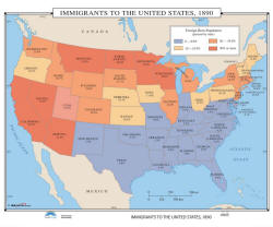
Immigrants in United States - History Wall Map Item # 30128 Sale: $99.99 - $539.99 (free ship/h) Immigrants to the US, 1890 shows, by color and percentages, each state and its foreign-born population. Color-coding identifies areas with less than 10%; areas with 10-19.9%; areas with 20-29.9%; and areas with 30% or more. |
 |
|
|
|
|
|||
|
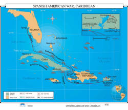
Spanish American War - US History Wall Map Item # 30137 Sale: $99.99 - $539.99 (free ship/h) The Spanish-American War took place in 1898, and resulted in the United States having control over the former colonies of Spain, in the Caribbean. Classroom wall map identifies Spanish territory, other areas, US and Spanish forces, US victories, and the US naval blockade. |
 |
|
|
|
|
|||
|
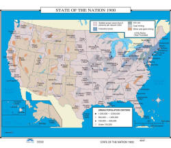
State of the Nation 1900 - US History Wall Map
Item # 30140 Sale: $99.99 - $539.99 (free ship/h) School wall map shows settled areas; industrial areas; iron ore centers; coal mining; silver and gold mining; and urban population centers, as well as an inset of Alaska. |
 |
|
|
|
|
|||
|
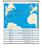
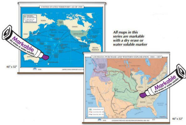
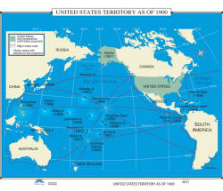
US Territories in 1900 - US History Wall Map Item # 30092 Sale: $99.99 - $539.99 (free ship/h) The United States Territory as of 1900 wall map shows the United States and possessions, with the year acquired. Map also shows major trade routes. |
 |
|
|
|
|
|||
|
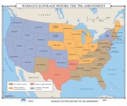
Women's Suffrage 1919 - US History Wall Map Item # 30146 Sale: $99.99 - $539.99 (free ship/h) Woman’s Suffrage Before the 19th Amendment identifies areas where there was no voting for women, areas where women could vote in presidential elections, areas where women could vote in primaries, and areas that enjoyed complete voting rights for women. |
 |
|
|
|
|
|||
|
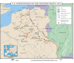
US Participation in World War I - History Wall Map Item # 30149 Sale: $99.99 - $539.99 (free ship/h) The US Participation on the Western Front, 1918 wall map identifies allied areas; Central Powers areas; nations that remained neutral; the Armistice Line of 1918; German and US offensives; Allied victories; and more. |
 |
|
|
|
|
|||
|
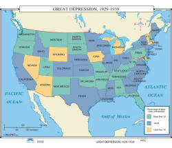
Great Depression - US History Wall Map Item # 30155 Sale: $99.99 - $539.99 (free ship/h) Pull down wall map shows states that had less than 10% of the labor force unemployed; 18-24% unemployed; and more than 25% unemployed. |
 |
|
|
|
|
|||
|
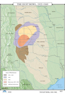
The Dust Bowl, 1935 to 1940 - US History Wall Map Item # 30158 Sale: $99.99 - $539.99 (free ship/h) The Dust Bowl, lasted close to a decade, overall. The area impacted the most was the southern Plains. This phenomenon caused massive people movements, which were described in John Steinbeck’s The Grapes of Wrath. |
 |
|
|
|
|
|||
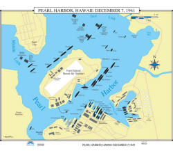
|
Pearl Harbor, 1941 - US History Wall Map Item # 30164 Sale: $99.99 - $539.99 (free ship/h) The attack on Pearl Harbor, Hawaii: December 7, 1941 removed the United States Navy’s battleship force as a possible threat or deterrent to Japan’s southern expansion. This action resulted in America’s immediate involvement in the Second World War. |
 |
|
|
|
|
|||
|
(1) 35,000 BC - 1776 AD (2) 1776 - 1812 (3) 1846 - 1857 (4) 1860 - 1877 (5) 1870 - 1941 (6) 1949 - 1999 (7) Wars Abroad |
|||
|
|
|||
|
|
Are you placing an order for a school or nonprofit?
Please submit your valid exemption certificate to traveler@1ststoptravelstore.com
Call us toll-free 877-822-9889 or 812-333-2772 for orders/questions Mon.-Sat. 10:00 am-5:30 pm Eastern Standard Time
Early 20th Century History of the United States - Pull Down Classroom Wall Maps on Rollers by KP, Item # 302xx
Sale Price: $119.99 - $899.99, Educational pull down world maps for students of history, classroom maps on rollers, school maps, spring roller maps, roll down maps for classrooms, large world maps
|
Home | Products | About Us | Contact Us | Helpful Links | Order, Return & Privacy Policies | Site Map | International Orders |
||||||||||||||
|
|
|||||||||||||
|
Site Map | Privacy Policy | Easy Return/Exchanges | APO/FPO Orders | No Minimum Order + FREE Shipping (contiguous USA) |
||||||||||||||