|
||||
|
||||
|
![]()
![]()
![]()
![]()
![]()
![]()
|
||||
|
||||
|
![]()
![]()
![]()
![]()
![]()
![]()
Durably Laminated U.S. History Classroom Wall Maps
Available as individual maps or multi-map sets, these wall maps are ideal for public, private, parochial, and home schools—as well as history lovers everywhere.
Please click here to view Map Mounting Setup Options Mounting hardware is included with your map order. When ordering a set, please indicate map item number and title in the Special Instructions Section of the secure Shopping Cart below.
|
|
|||||||||||||||||||||||||||
|
Purchase Orders Accepted - U.S. educational institutions and government agencies can place orders via official purchase order. Please email your PO to traveler@1ststoptravelstore.com
|
||||||||||||||||||||||||||||
|
To order single history maps please use "Add to Shopping Cart" buttons next to each map (arranged by approximate dates) |
|||
|
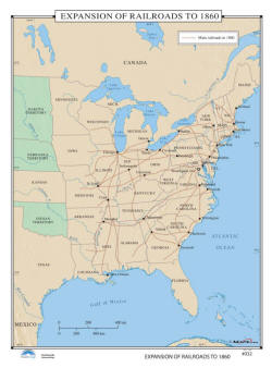
Railroad Expansion up to 1860 -
US History Wall Map Item # 30095 Sale: $99.99 - $539.99 (free ship/h) Classroom wall map identifies rail routes throughout the East and Midwest, and on into the Western territories of Dakota, Nebraska, and Indian territory north of Texas. |
 |
|
|
|
|
|||
|
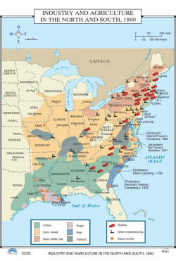
Economy in the North & South - US History Wall Map Item # 30098 Sale: $99.99 - $539.99 (free ship/h) Bright colors and images identify the areas of cotton; corn and wheat; dairy cattle and hay; sugar; rice; tobacco; textiles; manufacturing; and slave revolts on the Industry & Agriculture in the North & South, 1860wall map. |
 |
|
|
|
|
|||
|
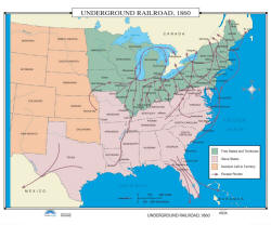
Underground Railroad - US History Wall Map Item # 30101 Sale: $99.99 - $539.99 (free ship/h) There was extensive activity on the Underground Railroad, 1860. Escape routes could be found primarily in the free states and territories; however, some were established in the slave states, as they traveled to the free states or to Mexico. |
 |
|
|
|
|
|||
|
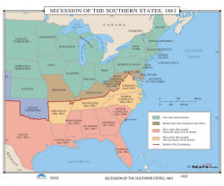
Southern States Secession - US History Wall Map
Item # 30104 Sale: $99.99 - $539.99 (free ship/h) Leading up to the U.S. Civil War, the Secession of the Southern States in 1861 was a very significant moment in U.S. history. Different shaded areas on the classroom wall map include: free states and territories, border states that remained in the Union, slave states that seceded before the attack on Fort Sumner, and slave states that seceded after the attack on Fort Sumner. |
 |
|
|
|
|
|||
|
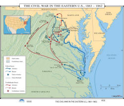
Civil War in Eastern US - History Wall Map Item # 30107 Sale: $99.99 - $539.99 (free ship/h) The Civil War in the Eastern US (1861-1862) separates the Union and Confederate states, by color. Map also shows Union and Confederate forces, retreats, victories, and the Union blockade. |
 |
|
|
|
|
|||
|
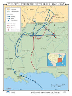
Civil War in Central US - History Wall Map Item # 30110 Sale: $99.99 - $539.99 (free ship/h) The Civil War in the Central US, 1862-1863 pull down wall map on roller identifies both Confederate and Union States, plus advances, retreats, and victories for both sides. |
 |
|
|
|
|
|||
|
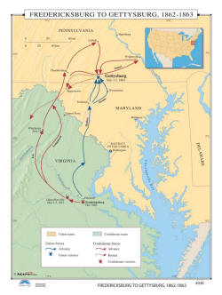
The Gettysburg Campaign - US History Wall Map Item # 30113 Sale: $99.99 - $539.99 (free ship/h) The Fredericksburg to Gettysburg, 1862-1863 classroom wall map is a fascinating snap shot of the U.S. Civil War. View Union and Confederate forces, advances and retreats in vivid colors. Showing the States of Pennsylvania, Maryland, Delaware and Virginia, this map is an excellent reference tool focusing on Fredericksburg and Gettysburg. |
 |
|
|
|
|
|||
|
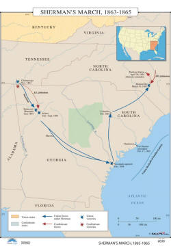
General Sherman's March - US History Wall Map Item # 30116 Sale: $99.99 - $539.99 (free ship/h) Sherman’s March to the Sea was the beginning of the end for South Carolina and the Confederacy. In 1864, the Confederacy was beginning its fall. Wall map of 1863-1865 shows the movement of Union and Confederate forces and their victories. |
 |
|
|
|
|
|||
|
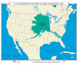
US Expansion & Alaska Purchase - US History Wall Map Item # 30119 Sale: $99.99 - $539.99 (free ship/h) Classroom wall map focuses on the Russian government’s offer to sell Alaska to the US in 1866. Russia and Secretary of State Seward worked out a treaty, under which the US would purchase Alaska for $7.2 million in gold; this deal became known as ‘Seward’s Folly’, until the gold strike of 1896. |
 |
|
|
|
|
|||
|
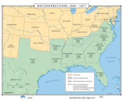
The Reconstruction Period - US History Wall Map Item # 30125 Sale: $99.99 - $539.99 (free ship/h) The Reconstruction, 1868-1877 school wall map shows the Union and former Confederate states, dates of readmission to the Union, and the dates for the reestablishment of a conservative government. |
 |
|
|
|
(1) 35,000 BC - 1776 AD (2) 1776 - 1812 (3) 1846 - 1857 (4) 1860 - 1877 (5) 1870 - 1941 (6) 1949 - 1999 (7) Wars Abroad |
|||
|
|
|||
|
|
Are you placing an order for a school or nonprofit?
Please submit your valid exemption certificate to traveler@1ststoptravelstore.com
Call us toll-free 877-822-9889 or 812-333-2772 for orders/questions Mon.-Sat. 10:00 am-5:30 pm Eastern Standard Time
United States Civil War Years Pull Down Classroom Wall Maps on Rollers by KP, Item # 302xx
Sale Price: $119.99 - $899.99, Educational pull down world maps for students of history, classroom maps on rollers, school maps, spring roller maps, roll down maps for classrooms, large world maps
|
Home | Products | About Us | Contact Us | Helpful Links | Order, Return & Privacy Policies | Site Map | International Orders |
||||||||||||||
|
|
|||||||||||||
|
Site Map | Privacy Policy | Easy Return/Exchanges | APO/FPO Orders | No Minimum Order + FREE Shipping (contiguous USA) |
||||||||||||||