|
||||
|
||||
|
![]()
![]()
![]()
![]()
![]()
![]()
|
||||
|
||||
|
![]()
![]()
![]()
![]()
![]()
![]()
Durably Laminated U.S. History Classroom Wall Maps
Available as individual maps or multi-map sets, these wall maps are ideal for public, private, parochial, and home schools—as well as history lovers everywhere.
Please click here to view Map Mounting Setup Options Mounting hardware is included with your map order. When ordering a set, please indicate map item number and title in the Special Instructions Section of the secure Shopping Cart below. |
|
|||||||||||||||||||||||||||
|
Purchase Orders Accepted - U.S. educational institutions and government agencies can place orders via official purchase order. Please email your PO to traveler@1ststoptravelstore.com
|
||||||||||||||||||||||||||||
|
To order single history maps please use "Add to Shopping Cart" buttons next to each map (arranged by approximate dates) |
|||
|
Post World War II -
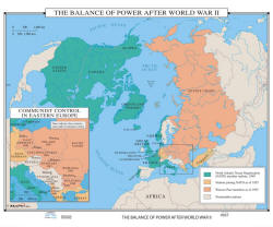
US History Wall Map Item # 30170 Sale: $99.99 - $539.99 (free ship/h) The Balance of Power After World War II wall map includes NATO member nations as of 1949; countries joining as of 1955; the Warsaw Pact members and non-member nations. Map includes an informative inset map showing Communist control of Eastern Europe. |
 |
|
|
|
|
|||
|
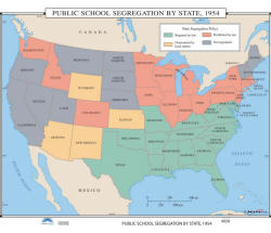
Public School Segregation by State, 1954 - History Wall Map Item # 30176 Sale: $99.99 - $539.99 (free ship/h) Pull down wall map shows which states required segregation by law; which states prohibited it; where it was determined by local options; and where it was not legislated. |
 |
|
|
|
|
|||
|
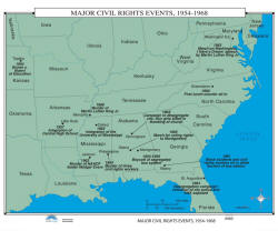
Major Civil Rights Events 1954 to 1968 - US History Wall Map Item # 30179 Sale: $99.99 - $539.99 (free ship/h) Wall map includes the 1954 Brown v. Board of Education ruling; the 1963 March on Washington/”I Have a Dream” Speech; the first lunch counter sit-in, in 1960; the 1968 murder of Martin Luther King, Jr.; the 1962 integration of the University of Mississippi; and several racial murders. |
 |
|
|
|
|
|||
|
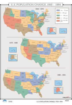
US Population Changes 1950 to 1994 - US History Wall Map
Item # 30223 Sale: $99.99 - $539.99 (free ship/h) Wall map provides three maps, representing specific time periods: 1950-1970; 1970-1980; and 1980-1994. Color-coding is used to identify five ranges of population change, from 5% or less to 50% or more. |
 |
|
|
|
|
|||
|
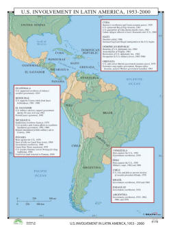
US Involvement in Latin America 1953 to 2000 - US History Wall Map Item # 30470 Sale: $99.99 - $539.99 (free ship/h) School map names the countries and events the United States was involved in, with a number of Latin American countries during the second half of the 20th. |
 |
|
|
|
|
|||
|
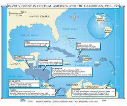
US Involvement in Central America & Caribbean,
1895 to 1930 - US History Wall Map Item # 30131 Sale: $99.99 - $539.99 (free ship/h)
|
 |
|
|
|
|
|||
|
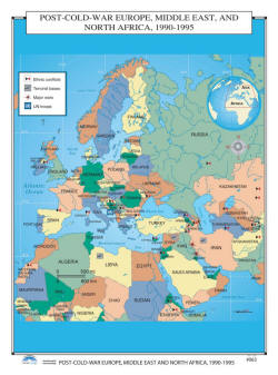
Post Cold War Europe, Middle East & North
Africa - History Wall Map Item # 30188 Sale: $99.99 - $539.99 (free ship/h) The Post-Cold War Europe, Middle East, & North Africa, 1990-1995 pull down wall map is a colorful wall map, identifying four major entities: ethnic conflicts, terrorists bases, major wars, and UN troop locations. |
 |
|
|
|
|
|||
|
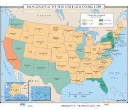
Immigrants to the United States 1990 - History Wall Map Item # 30191 Sale: $99.99 - $539.99 (free ship/h) Immigrants to the United States, 1990 is broken down into four areas: 0-4.9%, 5-9.9%, 10-19.9%, and 20% or more; and includes inset maps of Alaska and Hawaii. |
 |
|
|
|
|
|||
|
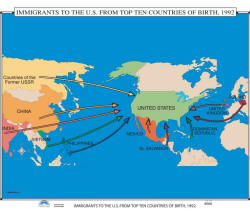
Immigration Origin Countries to US, 1992 - History Wall Map Item # 30197 Sale: $99.99 - $539.99 (free ship/h) Wall map color-codes the top ten countries of birth, including countries from the former USSR, China, Vietnam, India, Mexico, Dominican Republic, United Kingdom, and more. |
 |
|
|
|
|
|||
|
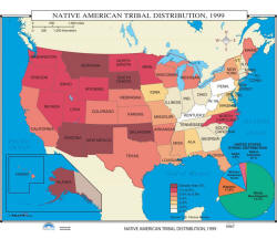
Native American Tribal Distribution 1999 - US History Wall Map Item # 30200 Sale: $99.99 - $539.99 (free ship/h) Classroom wall map shows, by state, the percentages of Native Americans in the US. Also provides the United States ethnic distribution, by percentages of White, Hispanic, African American, Asian, and Native American, in an inset pie chart. |
 |
|
|
|
|
|||
|
(1) 35,000 BC - 1776 AD (2) 1776 - 1812 (3) 1846 - 1857 (4) 1860 - 1877 (5) 1870 - 1941 (6) 1949 - 1999 (7) Wars Abroad |
|||
|
|
|||
|
|
Are you placing an order for a school or nonprofit?
Please submit your valid exemption certificate to traveler@1ststoptravelstore.com
Call us toll-free 877-822-9889 or 812-333-2772 for orders/questions Mon.-Sat. 10:00 am-5:30 pm Eastern Standard Time
United States History Wall Maps - Pull Down Classroom Wall Maps on Rollers by KP, Item # 302xx
Sale Price: $119.99 - $899.99, Educational pull down world maps for students of history, classroom maps on rollers, school maps, spring roller maps, roll down maps for classrooms, large world maps
|
Home | Products | About Us | Contact Us | Helpful Links | Order, Return & Privacy Policies | Site Map | International Orders |
||||||||||||||
|
|
|||||||||||||
|
Site Map | Privacy Policy | Easy Return/Exchanges | APO/FPO Orders | No Minimum Order + FREE Shipping (contiguous USA) |
||||||||||||||